How Many Districts in Karachi? [Complete 2024 Guide]
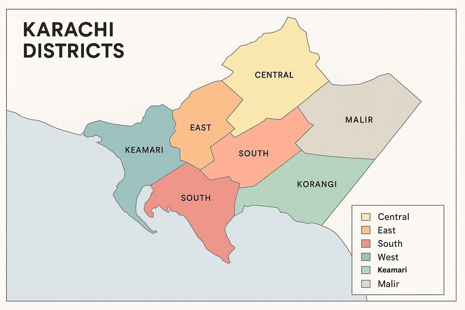
Karachi, the financial and cultural heartbeat of Pakistan, has seen its administrative map change several times in the past two decades. From the early town system to the reintroduction of districts, the city’s governance structure has been reshaped repeatedly to meet the needs of its growing population. As of 2025, Karachi is officially divided into seven districts: Central, East, South, West, Korangi, Malir, and Keamari.
Each district plays a distinct role in the city’s identity. Malir spans vast rural and semi-urban areas, making it the largest by land, while Central is the smallest in size but among the most densely populated in the country. Keamari, created in 2020, manages the port and coastal zones, while Korangi has grown into a hub for both industries and new housing schemes. Together, these districts form the backbone of Karachi’s governance, balancing its rich history with modern administrative needs.
This guide brings you a complete overview of Karachi’s districts — from the latest official count and updated names to area comparisons, population data, historic changes, and frequently asked questions. It is designed to give you a clear, reliable, and up-to-date reference to how the city is structured today.
Quick Answer — How Many Districts in Karachi?
As of 2024, Karachi is officially divided into 7 districts. Each district has its own municipal corporation and administrative boundaries, making it easier for the Sindh Government to manage the country’s largest city.
List of All 7 Districts in Karachi
- Central
- East
- South
- West
- Korangi
- Malir
- Keamari
Karachi Districts Map and Area Comparison
Each district in Karachi is distinct in size, population, and urban density. Malir is the largest district by area, while Central is the smallest but among the most crowded. These differences explain why some districts struggle with congestion while others remain more open and suburban in character.
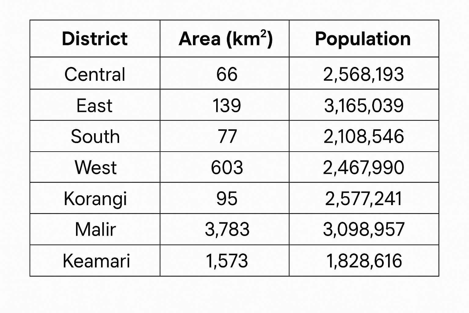
Karachi Districts by Area and Population
To make this clearer, here’s a comparison checklist of Karachi’s districts:
- Malir: Largest district by land area, with a mix of urban and rural zones.
- Central: Smallest district, but one of the most densely populated.
- Korangi: Important industrial hub with growing residential areas.
- Keamari: Coastal district established in 2020, including the port area.
History of Karachi’s Districts (2001–2024)
Karachi’s administrative divisions have been reshaped several times over the last two decades. Until 2001, the city was managed as a single district. Afterward, reforms were introduced to improve governance in the rapidly expanding metropolis.
Timeline of Administrative Changes
- 2001: Karachi was reorganized into 18 towns under a devolution plan.
- 2011: The town system was dissolved, and Karachi reverted to being a single district.
- 2013: Five districts were reintroduced, followed later by the creation of Korangi as a separate district.
- 2020: Keamari district was carved out of Karachi West, becoming the seventh district.
- 2024: Proposals were announced to rename four districts — Central to Nazimabad, East to Gulshan, West to Orangi, and South to Karachi.
What’s New for 2024? Renaming and Proposed Changes
The Sindh Government has approved renaming four of Karachi’s districts to reflect their central urban identities. While the total number of districts remains seven, their new titles bring them closer to the neighborhoods they represent.
Renaming of 4 Districts Explained
- Central → Nazimabad: Reflecting one of the most recognized residential areas in the district.
- East → Gulshan: Named after Gulshan-e-Iqbal, a landmark neighborhood.
- West → Orangi: Known for Orangi Town, one of Asia’s largest informal settlements.
- South → Karachi: Retaining the city’s name to reflect its downtown core.
These changes are part of a broader plan to simplify administrative names and align them with local identities. However, many official documents and maps still reference the old district names, so both sets are used interchangeably at present.
Administrative Setup of Karachi Districts
Each of Karachi’s districts is overseen by a District Municipal Corporation (DMC). These local bodies are responsible for services such as waste management, infrastructure maintenance, and community facilities. The DMCs work under the broader supervision of the Sindh Government and the office of the Commissioner Karachi.
District Municipal Corporations (DMCs)
There are seven DMCs corresponding to the seven districts. Their role is to manage local services and ensure that residents have access to essential municipal functions in a city of more than 20 million people.
Towns and Union Councils Breakdown
Below the district level, Karachi is subdivided into towns and union councils. According to the latest data, the city has 25 towns and over 240 union councils. These local councils form the grassroots of governance, helping manage day-to-day community issues.
Population and Census Data of Karachi Districts
Karachi is Pakistan’s largest city and its districts show huge differences in both size and density. The 2023 census recorded more than 20 million residents across the seven districts, with Malir covering the largest land area and Central being the most crowded.
Largest and Smallest Districts by Area and Population
- Malir District: Covers around 3,783 km², making it the largest district by area. Its mix of rural and urban zones keeps its population density lower than central districts.
- Central District: Just 66 km² in size, but one of the most densely populated areas in Pakistan.
- Korangi: Rapidly growing industrial and residential hub.
- Keamari: A coastal district with significant port activity and fishing communities.
Heritage and Landmarks by District
Each district of Karachi is home to historic, cultural, or natural landmarks that represent the city’s heritage:
- South: Mazar-e-Quaid, Frere Hall, Empress Market.
- East: National Stadium and Gulshan-e-Iqbal parks.
- Central: Liaquatabad markets and historic residential areas.
- Malir: Chaukhandi Tombs, a UNESCO heritage site.
- Keamari: Karachi Port, Manora Island, and Clifton beaches.
FAQ — How Many Districts in Karachi?
How many districts are there in Karachi right now?
Karachi has 7 districts as of 2024: Central, East, South, West, Korangi, Malir, and Keamari.
What is the population of each Karachi district?
According to the 2023 census, Karachi’s total population is over 20 million. Malir and Korangi are among the fastest-growing, while Central remains the most crowded.
Which district is the largest in Karachi?
Malir is the largest by area, covering nearly 3,800 km².
Which district is the smallest in Karachi?
Central is the smallest district, just 66 km², but it houses one of the densest populations in the country.
When was Keamari district created?
Keamari was created in 2020 when it was carved out of Karachi West to improve governance of the port and coastal areas.
What are the new names of Karachi districts?
In 2024, proposals were approved to rename four districts: Central (Nazimabad), East (Gulshan), West (Orangi), and South (Karachi). The total count remains seven.
How many towns and union councils are in Karachi?
There are 25 towns and more than 240 union councils across Karachi’s seven districts.
Myth vs Fact — Karachi’s Districts
- Myth: Karachi has 18 districts.
Fact: The city is officially divided into 7 districts. The 18 number comes from confusion with the old town system introduced in 2001. - Myth: Keamari is just a part of Karachi West.
Fact: Keamari became a separate district in 2020. - Myth: The 2024 renaming created new districts.
Fact: The renaming only changed district titles, the total count remains 7.
Should You Move? Districts and Neighborhood Guide
Choosing where to live in Karachi often depends on lifestyle, work location, and budget. Each district offers a unique character:
- Central: Bustling markets, old neighborhoods, excellent food spots, but highly congested.
- East (Gulshan): Popular residential and educational hub, with access to main highways.
- South: Business and financial center, home to many historic landmarks.
- Korangi: Affordable housing and strong industrial presence.
- Malir: Open spaces, agriculture, and heritage sites; ideal for those who prefer less density.
- Keamari: Coastal areas, ports, and beaches, but still developing infrastructure.
Conclusion: Your Karachi District Guide
Karachi’s seven districts are the backbone of how this city of over 20 million people is organized and managed. From the historic lanes of Saddar in the South to the wide landscapes of Malir, each district tells a different story of urban life, heritage, and governance. With the 2024 renaming plans, the administrative map has been simplified, but the number of districts remains the same.
Author: ZunNurain Khalid — Travel & Tourism Specialist, Founder of ExploreX Pvt. Ltd., and advocate for sustainable tourism in Pakistan. With over a decade of experience in digital marketing and destination branding, ZunNurain has worked extensively on promoting Pakistan’s natural and cultural heritage.