History
The capital city of Pakistan, Islamabad is located in the northwest of the country on the Potohar Plateau. This area has been significant in history for being a part of the crossroads of Rawalpindi and the North West Frontier Province. The city was built in 1960 to replace Karachi as the Pakistani capital, which it has been since 1963. Due to Islamabad’s proximity to Rawalpindi, they are considered sister cities.
Just southwest of Islamabad, only about 9 miles (14 km) away, lies Rawalpindi, a major city in Punjab province. Rawalpindi itself served as Pakistan’s capital from 1959 to 1969, during the transition period between Karachi and the establishment of Islamabad. Today, the close relationship and near seamless boundary between the two cities make them central to the region’s administrative and cultural landscape.
Compared to other cities of the country, Islamabad is a clean, spacious, and quiet city with lots of greenery. The site of the city has a history going back to the earliest human habitations in Asia. This area has seen the first settlement of Aryans from Central Asia, ancient caravans passing from Central Asia, and the massive armies of Tamerlane and Alexander.
To the north of the city you will find the Margalla Hills. Hot summers, monsoon rains and cold winters with sparse snowfall in the hills almost summarize the climate of this area. Islamabad also has a rich wildlife ranging from wild boars to leopards.
After the formation of Pakistan in 1947, it was felt that a new and permanent Capital City had to be built to reflect the diversity of the Pakistani nation. It was considered pertinent to locate the new capital where it could be isolated from the business and commercial activity of the Karachi, and yet is easily accessible from the remotest corner of the country. A commission was accordingly set in motion in 1958, entrusted with the task of selecting a suitable site for the new capital with a particular emphasis on location, climate, logistics and defense requirements, aesthetics, and scenic and natural beauty.
The Meaning Behind the Name
The choice of the name “Islamabad” carries more than just geographic significance. Translating to “City of Islam” or sometimes interpreted as “City of Peace,” the name was deliberately selected to represent the nation’s core values and aspirations. It was meant to embody Pakistan’s identity, emphasizing its foundation as a country rooted in Islamic ideals and unity.
Population
512,933. Area: 906 sq. km Elevation: 494 to 610 m. above sea level
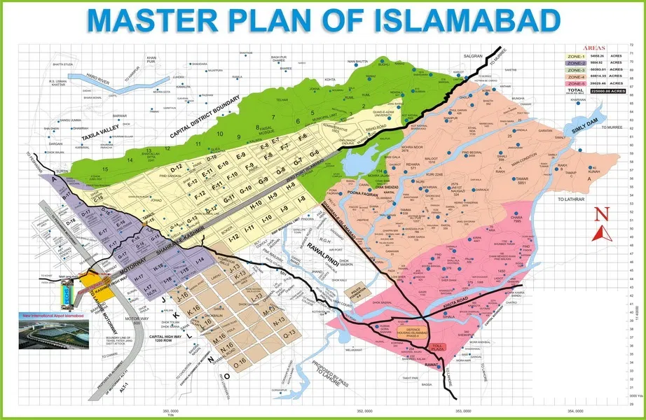
The master plan for the city was designed by Greek architect Constantinos Apostolou Doxiadis and divides the city into eight zones, including administrative, diplomatic enclave, residential areas, educational and industrial sectors, commercial areas, as well as rural and green areas which are administered by the Islamabad Metropolitan Corporation with support from the Capital Development Authority. Islamabad is known for the presence of several parks and forests, including the Margalla Hills National Park and the Shakarparian. It is home to several landmarks, with the most notable one being the Faisal Mosque, the largest mosque in South Asia and the fifth-largest in the world. Other landmarks include the Pakistan National Monument and Democracy Square.
Islamabad is a Gamma+ city as rated by the Globalization and World Cities Research Network. It has the highest cost of living in Pakistan, and its populace is dominated by middle and upper-middle-class citizens.
The city is home to twenty universities, including International Islamic University, Bahria University, Quaid-e-Azam University, PIEAS, COMSATS University and NUST. The city is rated as one of the safest in Pakistan, and has an expansive RFID-enabled surveillance system with almost 2000 active CCTV cameras.
Sectors of Islamabad
The five zones and sectors of Islamabad
Series A, B, and C are still underdeveloped. The D series has seven sectors (D-11 to D-17), of which only sector D-12 is completely developed. This series is located at the foot of Margalla Hills. The E Sectors are named from E-7 to E-17. Many foreigners and diplomatic personnel are housed in these sectors. In the revised Master Plan of the city, CDA has decided to develop a park on the pattern of Fatima Jinnah Park in sector E-14. Sectors E-8 and E-9 contain the campuses of Bahria University, Air University, and National Defence University. The F and G series contain the most developed sectors. F series contains sectors F-5 to F-17; some sectors are still underdeveloped. F-5 is an important sector for the software industry in Islamabad, as the two software technology parks are located here. The entire F-9 sector is covered by Fatima Jinnah Park. The Centaurus complex is a major landmark of the F-8 sector. G sectors are numbered G-5 through G-17. Some important places include the Jinnah Convention Center and Serena Hotel on G-5, the Red Mosque in G-6, the Pakistan Institute of Medical Sciences, the largest medical complex in the capital, located in G-8, and the Karachi Company shopping center on G-9.
The H sectors are numbered H-8 through H-17. The H sectors are mostly dedicated to educational and health institutions. The National University of Sciences and Technology covers a major portion of sector H-12. The I sectors are numbered from I-8 to I-18. With the exception of I-8, which is a well-developed residential area, these sectors are primarily part of the industrial zone. Two sub-sectors of I-9 and one sub-sector of I-10 are used as industrial areas. CDA is planning to set up the Islamabad Railway Station in Sector I-18 and the Industrial City in Sector I-17. Zone III consists primarily of the Margalla Hills and Margalla Hills National Park. Rawal Lake is in this zone. Zones IV and V consist of Islamabad Park and the rural areas of the city. The Soan River flows into the city through Zone V.
Development and Setbacks
After selecting the site for Islamabad in 1959 due to Karachi’s unsuitability, the city’s construction officially began in 1961. Planners aimed to blend traditional Islamic design elements with contemporary urban needs, and several renowned architects and town planners were invited to contribute to its unique layout.
However, Islamabad’s journey toward becoming a modern capital was not without interruptions. The early years saw swift progress, with the completion of key government buildings such as the Secretariat, Pakistan House, President’s House, National Assembly Building, and a grand mosque, as well as essential housing for government staff. The city’s commitment to education was evident with the founding of the University of Islamabad in 1965, followed by what would become the Allama Iqbal Open University in 1974.
But broader regional events played a role in shaping the city’s trajectory. In particular, the 1971 war with India temporarily halted the city’s development, as attention and resources were diverted to immediate national concerns. While the war caused a slowdown, Islamabad soon resumed its expansion, continuing its transformation into one of Pakistan’s most prominent and thoughtfully designed cities.
Architecture
Islamabad’s architecture is a combination of modernity and old Islamic and regional traditions. The Saudi-Pak Tower is an example of the integration of modern architecture with traditional styles. The beige-colored edifice is trimmed with blue tile works in Islamic tradition and is one of Islamabad’s tallest buildings. Other examples of intertwined Islamic and modern architecture include Pakistan Monument and Faisal Mosque. Other notable structures are Secretariat Complex designed by Gio Ponti, Prime Minister’s secretariat based on Mughal architecture, and the National Assembly by Edward Durell Stone.
The murals on the inside of the large petals of the Pakistan Monument are based on Islamic architecture. The Shah Faisal Mosque is a fusion of contemporary architecture with a more traditional large triangular prayer hall and four minarets, designed by Vedat Dalokay, a Turkish architect, and built with the help of funding provided by King Faisal of Saudi Arabia. The architecture of Faisal Mosque is unusual as it lacks a dome structure. It is a combination of Arabic, Turkish, and Mughal architectural traditions. The Centaurus is an example of modern architecture under construction in Islamabad. The seven-star hotel was designed by WS Atkins PLC. The newly built Islamabad Stock Exchange Towers is another example of modern architecture in the city.
Language
Languages by number of speakers in Islamabad
-
- Punjabi (52.23%)
-
- Pushto (18.50%)
-
- Urdu (12.23%)
-
- Hindko (6.40%)
-
- Other (10.64%)
According to the 2017 census, the mother tongue of the majority of the population is Punjabi at 52% (a decrease of 18% from the 1998 census), and a major dialect is Pothohari, 19% of the population are Pashto speakers, while an additional 12% speak Urdu, the national language, whereas the rest 17% speak other languages. Similarly, according to the 1998 census, the total migrant population of the city is 1 million, with the majority (691,977) coming from Punjab. Around 210,614 of the migrated population came from Sindh and the rest from Khyber Pakhtunkhwa and Azad Kashmir. Smaller populations emigrated from Balochistan, and Gilgit–Baltistan.
Literacy
The majority of the population lies in the age group of 15–64 years, around 59.38%. Only 2.73% of the population is above 65 years of age; 37.90% are below the age of 15. Islamabad has the highest literacy rate in Pakistan, at 88%. 9.8% of the population has done intermediate education (equivalent to grades 11 and 12). 10.26% have a bachelor’s or equivalent degree while 5.2% have a master’s or equivalent degree. The labor force of Islamabad is 185,213 and the unemployment rate is 15.70%.
Religion
-
- Islam – 95.43%
-
- Christianity – 4.34%
-
- Hinduism – 0.04%
-
- Others – 0.19%
Islam is the largest religion in the city, with 95.43% of the population following it. Christianity is the second largest religion is with 4.34% of the population following it. The Christians are concentrated mainly in the urban areas. Hinduism is followed by 0.04% of the population according to the 2017 census.
Economy
Islamabad is a net contributor to the Pakistani economy, as whilst having only 0.8% of the country’s population, it contributes 1% to the country’s GDP. Islamabad Stock Exchange, founded in 1989, is Pakistan’s third largest stock exchange after Karachi Stock Exchange and Lahore Stock Exchange, and was merged to form Pakistan Stock Exchange. The exchange had 118 members with 104 corporate bodies and 18 individual members. The average daily turnover of the stock exchange is over 1 million shares.
According to the World Bank’s Doing Business Report of 2010, Islamabad was ranked as the best place to start a business in Pakistan. Islamabad’s businesses are Pakistan’s most compliant for paying tax dues.[88] As of 2012, Islamabad LTU (Large Tax Unit) was responsible for Rs 371 billion in tax revenue, which amounts to 20% of all the revenue collected by Federal Board of Revenue.
Islamabad has seen an expansion in information and communications technology with the addition two Software Technology Parks, which house numerous national and foreign technological and information technology companies. Some jobs have relocated from India to Islamabad. Awami Markaz IT Park houses 36 IT companies, while Evacuee Trust house 29 companies. Islamabad will see its third IT Park by 2020, which will be built with assistance from South Korea.
Culture of Islamabad
Islamabad is home to many migrants from other regions of Pakistan and has a cultural and religious diversity of considerable antiquity. Due to its location on the Pothohar Plateau, remnants of ancient cultures and civilizations such as Aryan, Soanian, and Indus Valley civilizations can still be found in the region. A 15th-century Gakhar fort, Pharwala Fort is located near Islamabad. Rawat Fort in the region was built by the Gakhars in the 16th century and contains the grave of the Gakhar chief, Sultan Sarang Khan.
Saidpur village is supposedly named after Said Khan, the son of Sarang Khan. The 500-year-old village was converted into a place of Hindu worship by a Mughal commander, Raja Man Singh. He constructed a number of small ponds: Rama Kunda, Sita kunda, Lakshaman kunda, and Hanuman kunda. The region is home to a small Hindu temple that is preserved, showing the presence of Hindu people in the region. The shrine of Sufi mystic Pir Meher Ali Shah is located at Golra Sharif, which has a rich cultural heritage of the pre-Islamic period. Archaeological remains of the Buddhist era can also still be found in the region. The shrine of Bari Imam was built by Mughal Emperor Aurangzeb. Thousands of devotees from across Pakistan attend the annual Urs of Bari Imam. The event is one of the largest religious gatherings in Islamabad. In 2004, the Urs was attended by more than 1.2 million people.
The Lok Virsa Museum in Islamabad preserves a wide variety of expressions of the folk and traditional cultural legacy of Pakistan. It is located near the Shakarparian hills and boasts a large display of embroidered costumes, jewelry, musical instruments, woodwork, utensils, and folkloristic objects from the region and other parts of Pakistan.
Tourism in Islamabad
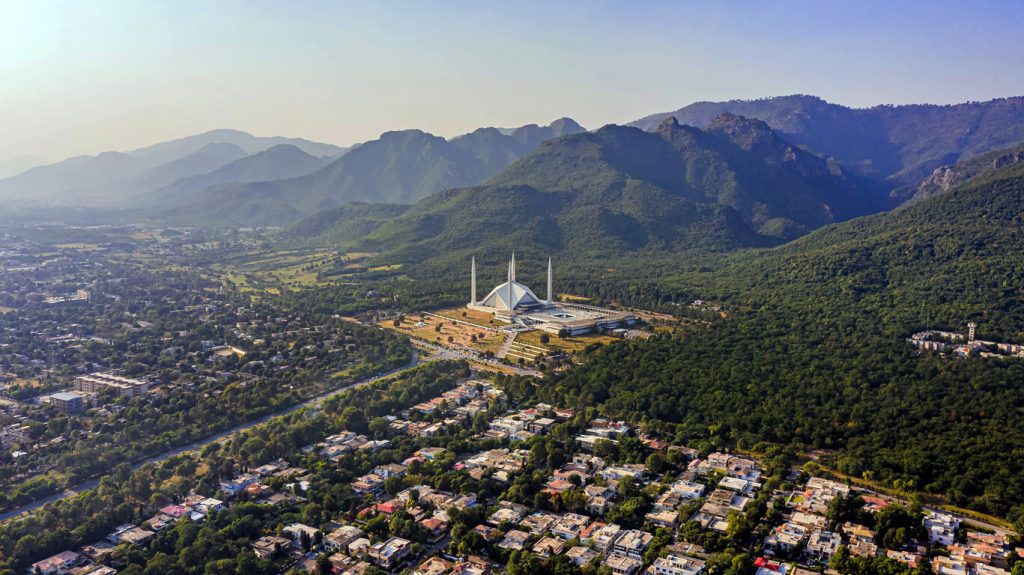
Faisal Mosque
Faisal Mosque is an important cultural landmark of the city and attracts many tourists daily. Faisal Mosque built in 1986, was named after the Saudi Arabian King, Faisal bin Abdul Aziz. It also serves the purpose of accommodating 24,000 Muslims that pray at this mosque. Faisal Mosque which is designed by the Turks and financed by the Kingdom of Saudi Arabia includes calligraphy of Quranic verses along the walls of the mosque.
One of the landmarks for tourists is the Pakistan Monument built in 2007 located in Islamabad. This tourist attraction represents the patriotism and sovereignty of Pakistan. The design is shaped as a dome with petal-shaped walls that are engraved with art portraying Pakistan’s other tourist landmarks such as the Badshahi Mosque, Minar-e-Pakistan, and Lahore Fort.
The Pakistan Monument
Islamabad holds some of Pakistan’s most prestigious museums such as Lok Virsa Museum, Institute of Folk and Traditional Heritage Shakarparian Park, and prominent galleries such as the National Art Gallery and Gallery 6.
The Islamabad Museum contains many relics and artifacts dating back to the Gandhara period of the region, an intriguing fusion of Buddhist and Graeco-Roman styles. The living culture of Islamabad and Pakistan is best explored at Lok Virsa Museum, as well as the Institute of Folk and Traditional Heritage in Shakarparian Park.
Islamabad is built upon civilization and architecture that ranges from the 10th Century to the modern era. As Islamabad is situated on the Potohar Plateau, the remains of civilization descending from the stone-age era include the Acheulian and the Soanian traditions and these are tourist landmarks. Islamabad has an array of historic landmarks that reflect the Hindu civilization that dates back to the 16th Century with examples such as Saidpur. Saidpur which is situated in Islamabad has progressed from a village to a sacred place that includes temples where the Hindu Mughal Commanders worshipped.
Margalla Hills National Park is located in the North sector of Islamabad and is in close proximity to the Himalayas. The National Park includes picturesque valleys and scenic hills that include various wildlife such as Himalayan goral, Barking deer, and leopards. Flanked by wildlife and vegetation, Margalla Hills National Park also includes accommodation and camping grounds for tourists.
Transport in Islamabad
Airport
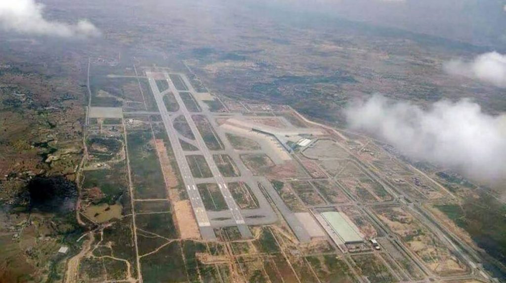
Islamabad is connected to major destinations around the world and domestically through Islamabad International Airport (IIAP). The airport is the largest in Pakistan and is located southwest of Islamabad. The new airport was inaugurated on 20 April 2018, spread over 19 square kilometers with 15 passenger boarding bridges, including facilities to accommodate two double-decker Airbus A380s, the world’s largest airplane, 15 remote bays, and 3 remote bays for Air cargo.
The airport itself is set amidst a landscape of natural terraces and meadows, part of the planned capital area that stretches across 350 square miles (906 square kilometers). This expanse is surrounded by a further 1,400 square miles (3,626 square kilometers) of carefully managed hinterland, with the majestic Margalla Hills rising 3,000 to 5,000 feet (900 to 1,500 meters) to the north and northeast. To the south, the terrain transitions into undulating plains, traversed by the Kurang River and anchored by the Rawal Dam, which creates a vast lake holding about 50,000 acre-feet (over 61 million cubic meters) of water. The airport’s location provides travelers with stunning views of Islamabad’s unique topography as they arrive or depart, truly setting the tone for the city’s blend of natural beauty and modern infrastructure.
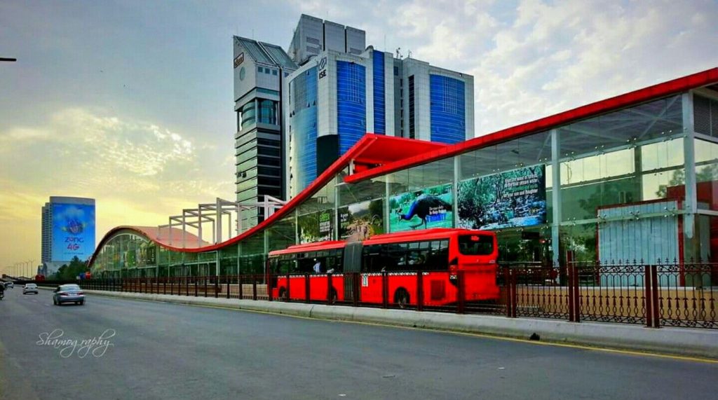
Metro Bus Service
The Rawalpindi-Islamabad Metrobus is an 83.6 km (51.9 mi) bus rapid transit system operating in the Islamabad-Rawalpindi metropolitan area. The Metrobus network’s first phase was opened on 4 June 2015, and stretches 22.5 kilometers between Pak Secretariat, in Islamabad, and Saddar in Rawalpindi. The second stage stretches 25.6 kilometres between the Peshawar Morr Interchange and New Islamabad International Airport and was inaugurated on 18th April 2022. On 7 July 2022, the Green Line and Blue Lines were added to this Metrobus network. The system uses e-ticketing and an Intelligent Transportation System and is managed by the Punjab Mass Transit Authority. This service is very reliable and consistent, and the labor force as well as students are using this government-provided service on a daily basis. It has reduced time consumption by reducing the route. Now, this bus service is being extended to more areas in Islamabad that including areas near G-13 and H-12. Work is being done to keep it along the Kashmir Highway.
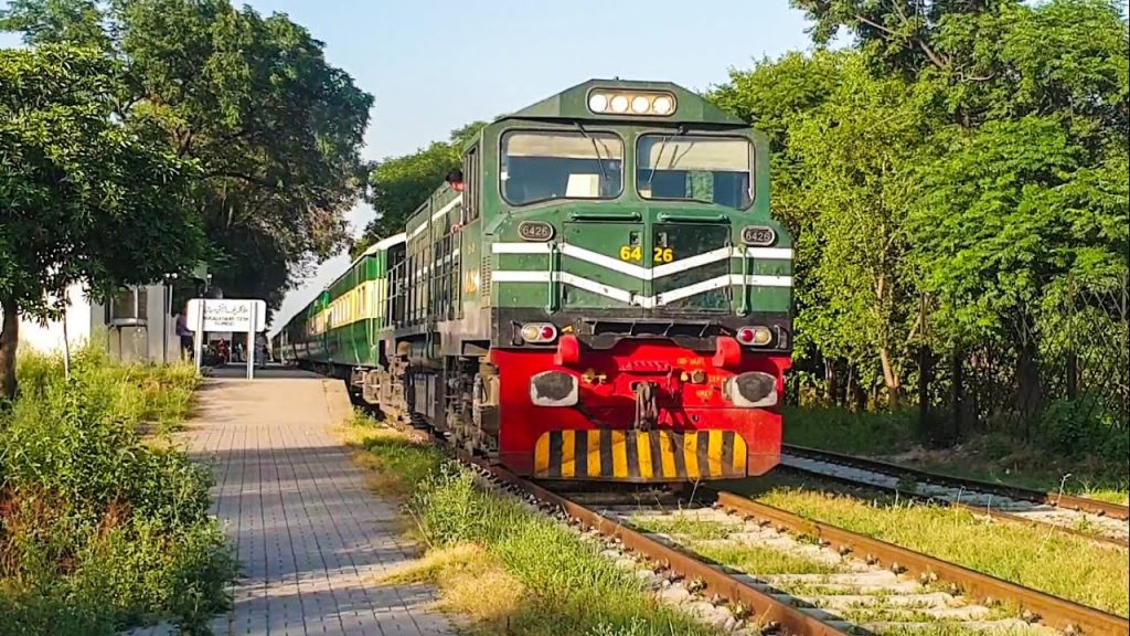
Railway Connection
The city is served by Pakistan Railways at Islamabad railway station.
Private Transport Apps
People use private transport like Taxis, Careem, Uber, Bykea, and SWVL for local journeys. In March 2016, Careem became functional in Islamabad and Rawalpindi with taxi services.
Roadways
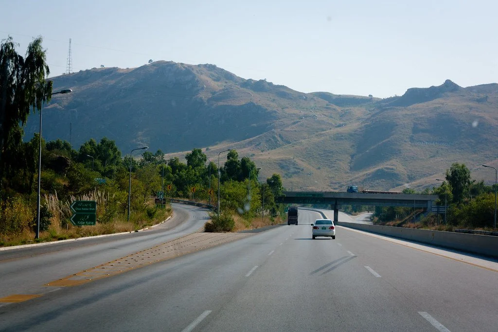
M-2 Motorway is 367 km (228 mi) long and connects Islamabad and Lahore.[120] M-1 Motorway connects Islamabad with Peshawar and is 155 km (96 mi) long.[120] Islamabad is linked to Rawalpindi through the Faizabad Interchange, which has a daily traffic volume of about 48,000 vehicles.
Sports
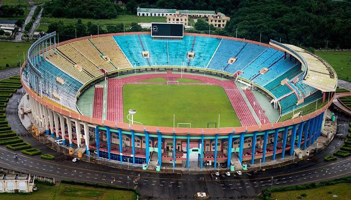
Islamabad has a multipurpose sports complex opposite Aabpara. It includes Liaquat Gymnasium for indoor games, Mushaf Squash Complex and Jinnah Sports Stadium for outdoor games, which is a venue for regular national and international events. 2004 SAF Games were held in the stadium. Some other sports venues of Islamabad include Diamond Club Ground, Shalimar Cricket Ground and Islamabad Golf Club.
There is another multipurpose sports complex in the F6 Markaz. It has tennis courts, a basketball court with fibre-glass boards and a Futsal ground which introduced artificial turf to the people of Islamabad.
Major sports in the city include cricket, football, squash, hockey, table tennis, rugby and boxing. The city is home to Islamabad United, which won the first ever Pakistan Super League in 2016 and second title in 2018, and Islamabad All Stars, which participates in the Super Kabaddi League.
Islamabad also has various rock climbing spots in the Margalla Hills.
Islamabad also has various rock climbing spots in the Margalla Hills.
The Margalla Hills themselves form a dramatic northern and northeastern boundary for the city, rising between 3,000 and 5,000 feet (900 to 1,500 metres). These hills are part of a much larger planned capital area, encompassing natural terraces and meadows as far as the eye can see. The city’s surroundings include about 350 square miles (906 square km) of protected green space, while an additional 1,400 square miles (3,626 square km) of hinterland—often referred to as the Specified Areas—are carefully managed to preserve their natural beauty.
To the south of the city, the landscape shifts into gentle, undulating plains, drained by the Kurang River. Here, the Rawal Dam creates a picturesque lake that holds about 50,000 acre-feet (around 61 million cubic metres) of water, serving as both a scenic spot and an important water reservoir for the region.
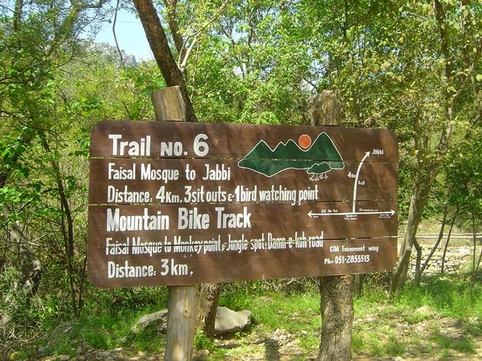
The most famous and oldest hiking track in Islamabad is Trail 3. It starts from Margalla Road in sector F-6/3. Due to steep hills, the trail is exhausting to some extent. The course leads to the point where it goes up to the Viewpoint and is about a 30 – 50 minutes track. After the Viewpoint, it continues for another easy-going 45 – 60 minutes and reaches the Pir Sohawa, where there are two restaurants for food, The Monal, and La Montana. In total, it is approximately a one-hour and thirty-minute walk.
Located in Islamabad, the Pakistan National Monument is a representation of the four provinces and three territories of the nation. Designed by the famous architect, Arif Masood, this blooming flower-shaped structure reflects the progress and prosperity of Pakistan.
Map of Islamabad
Planning and Construction
Construction of Islamabad formally began in 1961, with a deliberate approach to harmonize traditional Islamic design with modern city planning concepts. Esteemed planners and architects, including Constantinos Apostolou Doxiadis, were instrumental in shaping the city’s blueprint. Islamabad was designed to be compact—spanning approximately 65 square kilometers—resting at elevations between 450 and 600 meters.
The early phases of development focused on establishing key government institutions. Significant milestones included the completion of the Secretariat, President’s House, National Assembly Building, Pakistan House, and the iconic Grand National Mosque. In tandem with administrative infrastructure, residential areas for government officials were developed to support the new seat of government.
The city’s commitment to education took shape quickly. The University of Islamabad (now Quaid-i-Azam University) was founded in 1965, followed later by the People’s Open University in 1974—now known as Allama Iqbal Open University—providing expanded higher education opportunities.
Despite initial momentum, national events also influenced construction. The 1971 conflict with India led to a temporary pause in major development projects. However, work soon resumed, steadily transforming Islamabad into the thoughtfully planned capital envisioned from the outset.
Rawal Dam and Its Utility
Adjacent to the city lies Rawal Dam, constructed on the Korang River in the early 1960s. This vital reservoir plays a key role in supplying water to both Islamabad and neighboring Rawalpindi, making it an essential part of the region’s infrastructure. Not only does Rawal Dam ensure a steady water supply for residential and municipal use, but it also supports the city’s parks, gardens, and green belts, helping to sustain Islamabad’s reputation for scenic beauty and lush landscapes.