The Complete 2026 Guide
- Length: 1,300 km from Hasan Abdal (Punjab) to Khunjerab Pass (China border)
- Khunjerab Pass altitude: 4,693 m / 15,397 ft world’s highest paved international border crossing
- Built: 1962–1979 by China and Pakistan jointly. Opened to tourists: 1986.
- Cost: ~810 Pakistani and ~200 Chinese workers died in construction one person per kilometer.
- Route: Follows the ancient Silk Road through Karakoram, Himalaya, and Hindu Kush mountain ranges.
- BBC Travel: Called it the ‘8th wonder of the world’
- The Guardian: Ranked it ‘third best’ road trip destination in the world.
- Passes through: Punjab → KPK → Gilgit-Baltistan → Khunjerab Pass (China border)
Most of the world’s great road trips require you to drive. The Karakoram Highway requires you to be driven the roads are not self-drive territory for first-time visitors but this is a minor distinction against what you are looking at out the window.
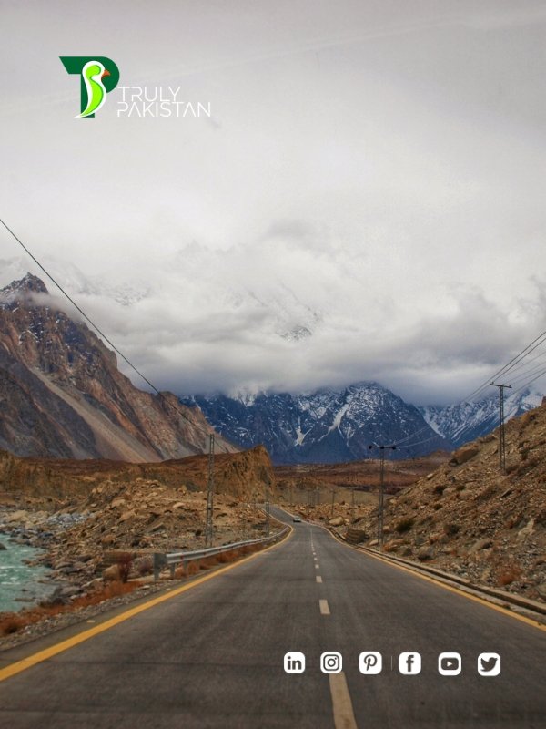
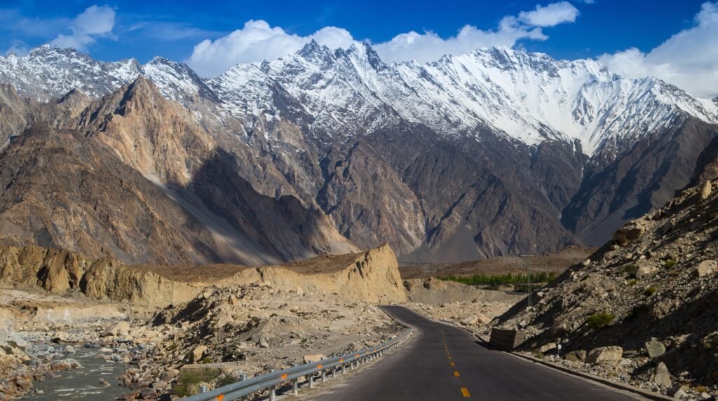
The KKH runs 1,300 kilometers from Hasan Abdal in Punjab to the Khunjerab Pass at 4,693 meters above sea level on the Chinese border. It passes through three of the world’s great mountain ranges the Karakoram, the Himalayas, and the Hindu Kush. On one section of road, you can look up at Nanga Parbat 8,126 meters, the ninth-highest peak in the world from the car window. That is not a selling point. That is what it is.
China and Pakistan built this road between 1962 and 1979. The statistics of construction involve approximately 810 Pakistani and 200 Chinese workers killed mostly in landslides and falls. One person per kilometer. The road was named after the mountain range that very nearly defeated the engineers who built it.
The Route: Islamabad to Khunjerab Pass
Most travelers drive the Pakistan-side route: Islamabad north through KPK to Gilgit, then northwest to Hunza, continuing to Khunjerab Pass at the Chinese border. The total drive time without stops is approximately 14–16 hours. With stops which is the only way to drive this road — the standard itinerary is 5–7 days minimum.
| Km | Stop | Altitude | Drive From ISB | Why Stop |
|---|---|---|---|---|
| ~70km | Taxila | 500m | 1.5 hrs | UNESCO World Heritage Buddhist ruins — 30-minute detour |
| ~170km | Abbottabad | 1,256m | 3 hrs | KKH officially begins here · Last major city before mountains |
| ~330km | Besham | 600m | 5–6 hrs | Indus River gorge begins · KKH lunch stop |
| ~470km | Dasu | 680m | 7–8 hrs | Karakoram scenery begins · Dasu dam construction visible |
| ~540km | Chilas | 1,250m | 9–10 hrs | Nanga Parbat visible in distance · Rock carvings nearby |
| ~610km | Raikot Bridge | 900m | 11 hrs | Fairy Meadows turnoff · Nanga Parbat visible directly |
| ~740km | Gilgit | 1,500m | 13–14 hrs | Transport hub · ATM · guesthouses · Kargah Buddha |
| ~840km | Karimabad, Hunza | 2,438m | 15–16 hrs | The destination · Baltit Fort · Eagle’s Nest · Attabad Lake |
| ~980km | Passu | 2,400m | 2 hrs from Hunza | Passu Cones · Batura Glacier · quiet guesthouse |
| ~1,050km | Sost | 2,790m | 3 hrs from Hunza | Last town before border · immigration checkpoint |
| ~1,100km | Khunjerab Pass | 4,693m | 4 hrs from Hunza | World’s highest paved border · Khunjerab National Park |
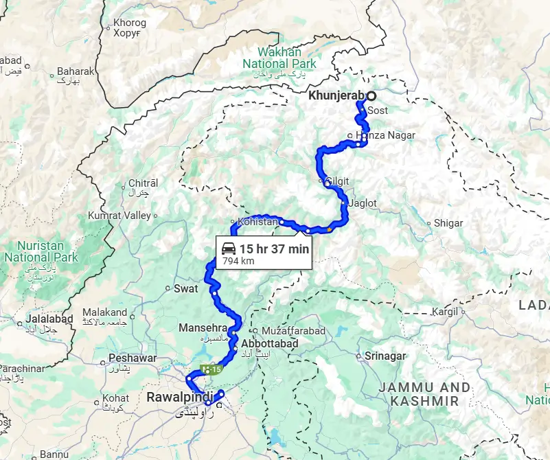
Image Source:https://rozefstourism.com/tour/khunjerab-pass-tour-package/
The Four Sections That Make the KKH
Section 1: Islamabad to Chilas Where It Gets Serious
The drive out of Islamabad through Abbottabad and into the Indus gorge is the transition from Pakistan’s lowland world to its mountain world. By Besham, the Indus River is running alongside the road in a gorge that narrows continuously as you drive north. By Chilas 1,250 meters, the gateway to Nanga Parbat — the mountains have fully arrived. Ancient rock carvings at Chilas date back thousands of years; petroglyphs of ibex, hunters, and Silk Road travelers are carved into boulders along the river bank.
Section 2: Chilas to Gilgit The Nanga Parbat Section
Between Chilas and Gilgit, the road passes the Raikot Bridge the turnoff point for Fairy Meadows and Nanga Parbat Base Camp. From certain points on this stretch of highway, Nanga Parbat (8,126 meters) is visible directly from the road. The BBC Travel guide described it as ‘perhaps one of the only places in the world where you can admire an 8,000-meter mountain from the window of your car.’ This is accurate. For those wanting to stop and trek, read our full Fairy Meadows guide.
Section 3: Gilgit to Hunza — The Scenic Peak
The 95-kilometer drive from Gilgit to Karimabad in Hunza is the single most photographed stretch of the KKH. Rakaposhi (7,788 meters) is visible for much of the drive. The road narrows and climbs, the Hunza River runs below, and the valley opens eventually to reveal the terraced orchards and ancient forts of Karimabad. This section should not be rushed. Read our Hunza travelogue for what awaits you at the end of this drive.
Section 4: Hunza to Khunjerab Pass — The High Road
From Karimabad, the road continues through Attabad Lake — formed when a 2010 landslide blocked the Hunza River, creating a turquoise lake inside a canyon and on past the Passu Cones (distinctive pointed peaks at 6,106 meters), through Gulmit and Sost, and up to the Khunjerab Pass at 4,693 meters. At the pass, Marco Polo sheep are sometimes visible. The landscape is high-altitude desert with snow-covered peaks. Standing at the pass, you are at the same height as Mont Blanc’s summit.
The Key Stops — Detail
Attabad Lake
Attabad Lake sits inside the KKH corridor you cannot miss it. The lake is turquoise from glacial melt, contained within a narrow canyon, with a series of tunnels (blasted through the cliff after the 2010 landslide) carrying the highway above it. Boat rides on the lake are available and popular. The color of the water is not a photograph trick it is genuinely that turquoise. Stop here. The lake is 1 hour from Karimabad and accessible as a day trip from Hunza.
Karimabad, Hunza
Karimabad is the main town of Hunza Valley and the location of Baltit Fort (850 years old, restored by the Aga Khan Trust) and Altit Fort (1,100 years old). Eagle’s Nest viewpoint above Karimabad has seven Karakoram peaks visible simultaneously from a single point. The bazaar in Karimabad sells local crafts, dried apricots, and walnut oil. Allow at least two full days here. For a complete guide, read our Hunza Valley travel guide and our Hunza travelogue.
Khunjerab Pass
The Khunjerab Pass is open May 1 to November 30. Entry to Khunjerab National Park costs approximately $20. At the top, a monument marks the Pakistan-China border. The drive from Karimabad is about 4 hours through progressively more dramatic high-altitude scenery. There is nothing at the pass except altitude, views, and the knowledge that you are at 4,693 meters at the top of the world’s highest paved road.
Practical Planning
Best months: May–October (peak: June–August for max daylight and warmth)
Khunjerab Pass: Open May 1 November 30 only
Self-drive: Not recommended for first-time visitors hire a local driver
Driver cost: $40–70/day essential investment for road knowledge and safety
Landslide risk: July–August monsoon season brings occasional blockages — build buffer days
Islamabad to Hunza by road: 14–16 hrs (recommend 2-day drive with Chilas overnight)
Islamabad to Gilgit by domestic flight: 1 hr — fly up, drive down for best of both
Pakistan eVisa: Required for US passport holders — apply at visa.nadra.gov.pk. Full guide: Pakistan Visa for US Citizens
FAQs Karakoram Highway
One person died for each kilometer of the Karakoram Highway’s construction. That number not dramatic in the telling, just factual — explains something about what it cost to open this road to the world. The least you can do is drive it.
Before you travel, make sure you have applied for your Pakistan Tourist eVisa, read our Pakistan safety guide, and explored our Complete Pakistan Travel Guide 2026.
Plan Your Pakistan Adventure — Start with TrulyPakistan